
By Douglas Doherty
The sweet track is a fine example of a Neolithic wetlands walkway and also one of the oldest known track ways in Europe dated back to 3806/3807BC using dendrochronology. The track is of wooden construction at an estimated length of a 2km and has been well preserved due to the peaty soils of the region (Jewkes 2013).
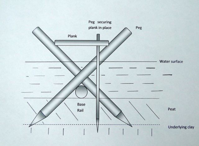
The construction of the trackway consisted of placing long wooden rails end to end onto the marsh then driving pairs of pegs obliquely into the peat either side of the rails so that they crossed over and formed a v, these were spaced roughly a meter apart. Resting on top of these were the planks of the walkway with notches sometimes cut into the planks to better fit more stably onto the pegs with occasional vertical pegs added for further stability. The trackway runs considerably straight in its path across the marsh from Westhay island across to the Polden Hill Slopes (Somerset HER n.d. a).
Sweet Track cross section (Wikipedia)
This example of a wetlands walkway was first discovered back in 1970 by a Mr Raymond Sweet after whom the track is named. The discovery took place on Shapwick Heath on the border of one of the large peat fields behind an old peat factory, when during the process of ditch clearing during the winter months an ash plank was discovered. The site of discovery was then investigated by John Coles and more planks as well as axed debris of wood were found together with pegs driven into the peat. Mr Sweet had also found a leaf shaped arrowhead in the vicinity as well as a number of flint flakes. Early conclusions were that it appeared to be Neolithic (Coles and Coles 1986: 38).
The goal for the project was to discover the extent and purpose of the sweet track and well as arranging its conservation (Coles and Coles 1986: 38). The team that was assembled to work on the Sweet Track for most of its excavation was relatively small but grew to consist of experts in several disciplines. Such members were John Coles, one of the first to start work on the site. Bryony Orme who started as a research student but later rose to supervisor and then co-director. With them Ruth Jones specialising in tree ring studies and conservation, and Alan Hibbert, an expert in peat and pollen (Coles and Coles 1986: 38). Throughout the excavation the project was fortunate in that the landowners, tenants and the peat company along the track way were very agreeable in giving permission to excavate and willing to delay work on areas around the needs of the excavation (Coles and Coles 1986: 41-42).
Excavation of the Factory site took place between 1970-1972 during which 56m of the track way were revealed. The planks (which were mostly in poor condition) were found to be almost level with different woods utilised for different areas and evidence of working on site revealed by the presence of wood chips (Somerset HER n.d. a). John Coles reflects on how during the summer excavation of 1970 they did not yet know how the track way had been constructed but tells how “it was totally unlike anything we had seen in the Levels, or read about elsewhere” (Coles and Coles 1986: 42) which suggests that at the time it could have been considered a very important find.
The Burtle site which revealed 12m of track was excavated between 1971-1972. The level of track way was noted to rise in its approach of the Burtle sand bank with other notable features being that the track appeared absent in dry sections and in others there was clay reinforcement of the track. This excavation also showed the utilisation of features such as an oak tree in the foundation of the track. The largest section of the Sweet Track to be excavated was the railway site from 1971-1975 in which 131.5m of the track way was revealed. This site was of particular importance and it showed that the track was more complex than previously anticipated with the presence of two tracks which had been built close and sometimes on top of each other (Coles and Coles 1986: 43). In places there were signs of additional reinforcement such as transverse timber below the rails, vertical pegs driven into the peat with the planks resting directly on them as well as evidence of peat packing to increase stability. There were also several finds dating from the Neolithic found in this site including notably a Jadeite axe (Somerset HER n.d. a).
In 1977 the Drove site was excavated, the 50m of the track way that was revealed showed similar construction methods to previous sections. The notable aspect of this section was that it showed the use of bundles of birch, willow, apple, alder for the rails of the track in the limited debris seen in the site (Somerset HER n.d. a). Further excavations have revealed such as those in 1981-1982 have shown that the track was designed to stand above the water level even in times of flood providing passage across the wetlands all year round (Somerset HER n.d. a). The main focus for the site currently is the management of its preservation particularly as the water table is lowering which threatens the preservation of the track (Somerset HER n.d. b). As measures to attempt to preserve the site an English Heritage funded project has been carried out to test the effectiveness of a water management strategy utilised in the Shapwick Heath National Nature reserve to preserve a 500m section of the track (Somerset HER n.d. b)
Bibliography
Coles, B. & J. Coles (1986) Sweet Track to Glastonbury: The Somerset Levels in Prehistory. London: Thames and Hudson.
Jewkes, M. (2013) The Sweet Track. Available online: http://www.ancient.eu/The_Sweet_Track/ [Accessed 15/11/2015]
Somerset HER (n.d. a) Sweet track, Shapwick Heath. Available online: http://www.heritagegateway.org.uk/Gateway/Results_Single.aspx?uid=10739&resourceID=100 [Accessed 15/11/2015]
Somerset HER (n.d. b) Evaluation and monitoring (1995), Sweet Track, Shapwick. Available online: http://www.heritagegateway.org.uk/Gateway/Results_Single.aspx?uid=17305&resourceID=100 [Accessed 15/11/2015]
